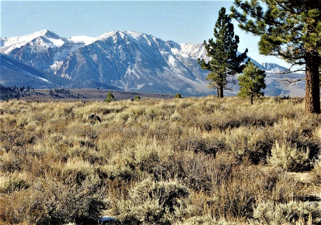
Panamint Mountains as seen from Death Valley, Death Valley National Park, jrc
Overview
My only visit to Death Valley National Park came in November 2000. Charlie and I had been to a conference in Reno, NV and decided to visit Lake Tahoe and Death Valley before returning home. Even in the late fall we found Death Valley to be hot, dry, and desolate. Even so, it had oases, such as the date orchard and an abandoned farm at Furnace Creek Ranch near the middle of the park.
It might seem strange to many that Death Valley is a National Park. Located in southeastern California, it is one of the harshest environments in the world. It is a desert that holds the all-time high-temperature record in the US at 134o F at Badwater, an overview in the park. Badwater also holds the record for lowest elevation in the US at 282 feet below sea level. And yet, to the geologist in me, it displays a unique geologic beauty and introduces visitors to an ecosystem with plants and animals that might not exist anywhere else in the country. There is also beauty in this harsh environment. On the face of the Black Mountains, located in the southwestern corner of Death Valley National Park can be found Artist’s Palette which is noted for a variety of bold colors caused by oxidation of various metals contained in the rocks and minerals of this area. The snow-covered Panamint Mountains (see photo above) are a component of the Pacific Coast Ranges. Mt. Whitney, in the nearby Sierra Nevada Range is the highest peak in the lower 48 at 14,505 feet. It is only about 85 miles northwest of Badwater, the lowest point in the lower 48.
Geologically, Death Valley is located in the Basin and Range province of southwestern US. Basin and range topography is an alternating landscape of parallel mountain ranges and valleys. This topography is thought to be caused by the rocks of the crust being forced upward by heat from the mantle below, and pulled apart until they fracture. In the Basin and Range province of southwestern US, this process causes some of the fractured blocks of rock to fall along vertical faults, creating a series of roughly parallel low areas called basins. The topographically high areas separating the basins are called ranges. Death Valley is an example of one such basin.
Environmental Concerns
Global Climate Change The 4th National Climate Assessment, Chapter 25 summarizes climate change effects in the southwestern part of the United States saying that the states of California, Nevada, Utah, Colorado, Arizona, and New Mexico will continue to experience higher temperatures, lower precipitation, more severe droughts, and more floods due to global climate change. (https://nca2018.globalchange.gov/chapter/25/) Death Valley is located in the eastern part of California and should expect to experience all of the above-mentioned effects. However, in this area predictions regarding precipitation are uncertain. From Climate Trends for the Area within Park Boundaries, even if precipitation increases, higher temperatures can cause most precipitation to evaporate causing the area to become even more arid. Extreme heat and extreme storms are both expected to increase. As temperatures rise, precipitation patterns may change. Plants and animals in the park may be pushed to find new homes or may even to succumb to these threats and become extinct. (https://irma.nps.gov/DataStore/DownloadFile/554921)
Air Quality From the National Park Service (NPS) website: “Since most of the land is treeless with a great range of elevations, the park has an abundance of striking and easily accessible views. Unfortunately, the view across the valley is often hazy, especially in the late spring and summer. On bad days, Telescope Peak is not visible from the visitor center, even though it is only 23 miles away.
One might think that the air would be pristine at Death Valley National Park due to its remote location. However, the general trend in upper air movement brings pollutants from metropolitan areas, industrial areas, and transportation corridors from the west. In summer, surface winds come from the southwest, where major population centers, industrial areas, and a dry lakebed are located. In winter, surface winds come from the northeast. Since these winds bring an air mass that originates in less developed areas, the air quality is better in the winter.
Pollutants carried in from other areas usually change form by the time they reach Death Valley. For example, sulfur dioxide and nitrogen dioxide emitted by power plants and cars react with other molecules to form sulfates and nitrates, which interfere with visibility and contribute to acid rain. Similarly, ozone is formed by nitrogen dioxide and volatile organic carbons. During the summer months, more sunlight and higher temperatures speed up these conversion reactions.
Nature also contributes to the haziness by blowing dust into the air. And humans increase the amount of dust available to be blown by the wind when they drive on unpaved roads or break up the salt crust by walking on it.
The park has an air quality monitoring station near Furnace Creek that measures ozone, wet and dry acid deposition, visibility-reducing particles, and meteorological data. The monitoring station is part of a nationwide network. Collecting long-term data on air pollutants allows the National Park Service to take action if they exceed certain standards. Also, this information allows us to predict bad air pollution days and inform visitors about how to reduce negative health effects on these days. Death Valley National Park currently measures ozone levels that are unhealthy for sensitive groups a few times a year. A system for forecasting high ozone days is in the works.”
Invasive Species Because there are many habitats available, and because of a long history of human use, Death Valley has a number of nonnative plant species within the park. Several species of tamarisk (salt cedar), native to the Eastern Hemisphere, were brought to the United States beginning in the early 1800s for ornamental plantings, erosion control, shade, and windbreaks. By 1913, tamarisk had invaded Death Valley, tamarisk was planted by pioneers, and even by the National Park Service during its early tenure of this park. Unfortunately, the tamarisk’s curse was not recognized soon enough. In the west, anywhere tamarisk gains a foothold it crowds out native plant and animal communities. It consumes excessive amounts of water, the key to life in the desert, and salinizes soils where its salty leaves drop. Today, tamarisk is one of the most abundant riparian (stream side) plants throughout the arid southwest and is unlikely to be fully removed from the park.
Water Availability As the place where the highest temperature on earth was recorded, it stands to reason that water in Death Valley would be a scarce commodity, and most of the time it is. However, occasional rains in the valley and the high lands surrounding it bring some water into the valley, allowing date farms in the area to exist.
Mining Impacts Death Valley has a long history of mining both metals and non-metals, including borax and the 20 Mule Team borax operations. From the NPS website: “Since the 1848 discovery of gold in California, Death Valley has experienced over 140 years of boom and bust mining. From the 1880s to the early 1900s, mining was limited and sporadic in the Death Valley region. Many of these early mining districts met with a notable lack of success. Primitive and inefficient technology, scarcity of water and fuel, and the difficulties of transportation made it economically impossible to mine any but the highest grade ores.”
The last mine closed in 2005, but all have left some scars. The park’s Resources Management Division continues to review the status of 19 patented mining claim groups and fewer than 10 unpatented mining claims while ensuring that federal guidelines are followed and the park’s resources are being protected.
Visitor Impacts From an article in the Pahrump Valley (newspaper) Times, 2019: “After more than a week following the longest government shutdown on record, services appear to be getting back to normal in Death Valley National Park. Officials at the site, according to a news release, are still assessing the shutdown’s impacts, as preliminary reports of human waste, trash, and vandalism have all come to light.”
To the Reader Most of my sources were web sites which I indicate by their address at the end of the quoted material or my summary thereof. All references which state only “NPS” with no web address refer to the web address for this park: https://www.nps.gov/deva/index.htm. This is where 90% of all material for this report was found, and this is where you should first look for additional material. Warning: This web site is highly complex and it is often difficult to find additional material.
