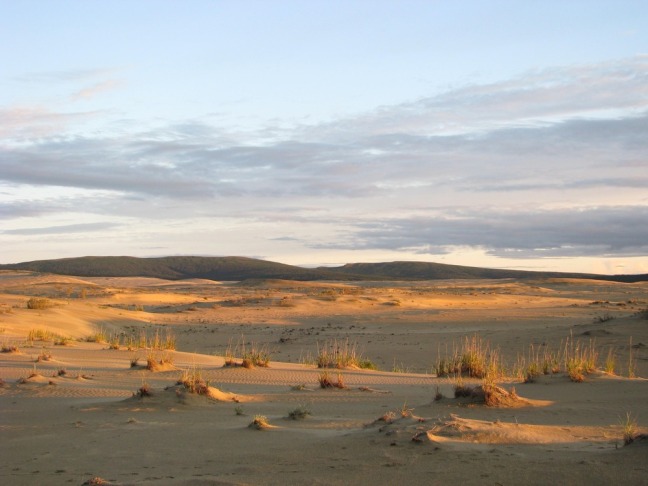
WHITE SANDS NATIONAL PARK

WHSA_dunefield[1]

White Sands Dunefield, White Sands National Park, photo courtesy National Park Service

Overview 

I have not yet visited the White Sands National Park, located in southern New Mexico. I grew up in neighboring Texas, and did two years of geological field work in northern New Mexico for my doctoral degree. I knew there was a White Sands National Monument in south Central New Mexico, established in 1933, and I also knew that White Sands Missile Range, site of the first atomic detonation in 1945, was located 65 miles north of the White Sands National Monument. I only recently discovered that the National Monument had been upgraded to National Park status near the end of 2019.

From the National Park Service (NPS) website: “Like a mirage, dazzling white sand dunes shimmer in the tucked-away Tularosa Basin in southern New Mexico. They shift and settle over the Chihuahuan Desert; covering 275 square miles…White Sands National Park preserves more than half of this oasis, its shallow water supply, and the plants and animals living here.” The Chihuahuan Desert is the coldest and wettest desert in North America. It covers a vast area, one third larger than all of New Mexico. This desert is located in three U.S. states and also in five Mexican states.

Around  3 0 million years ago, the tectonic plate in which White Sands National Park was located began to pull apart in opposite directions, causing the development of numerous fault zones.  As a result of this faulting, sections of the Earth’s crust dropped thousands of meters forming what is now known as the Tularosa Basin.

About three million years ago the Rio Grande River flowed along the southern edge of the Tularosa Basin, carrying sediments which were later deposited into the Tularosa Basin, eventually blocking its outlet to the sea.  Water that collected at the lowest point in the basin eventually blocking its outlet to the sea.  Water that collected at the lowest point in the base eventually formed a 1,600 square mile lake that covered much of the basin.

At the end of the most recent Ice Age, about 11,000 years ago, the climate started to warm. Rain and snow carried dissolved gypsum (a very soft, hydrated calcium sulfate mineral) from the surrounding mountain ranges and deposited it into what was to become Lake Otero. As temperatures warmed the water began to evaporate and the lake bed became a playa, or dry lake bed of gypsum.

Environmental Concerns

 Global Climate Change   The 4th National Climate Assessment, Chapter 25 summarizes climate change effects in the southwestern part of the United States saying that the states of California, Nevada, Utah, Colorado, Arizona, and New Mexico will continue to experience higher temperatures, lower precipitation, more severe droughts and more floods due to global climate change. (https://nca2018.globalchange.gov/chapter/25/)

From the National Park Service (NPS) website: “The White Sands dunefield is a sensitive ecosystem that relies on moisture to keep the dunes in place. If you dig just below the dune surface you will find wet sediment, and if you dig at the base of the dunes you will find groundwater only feet below.

Continued increases in temperature are expected under ongoing climate change. This may have a range of impacts on the dunes, including higher evaporation; lower water table under the dunes; hotter temperatures within the dunes; reduction of the soil moisture that stabilizes the dunes; and possibly reduced flooding events that trigger gypsum growth. As the dunes dry, the gypsum sand is increasingly able to move with the wind, and large-scale drying events have dramatic impacts on dunes and on visitor access to the dunes.” The image above was taken from space during a dry and windy period in 2008 when migrating dunes closed off the dune drive (the road that allows access into the heart of the dunes) in several locations for nearly two weeks. Understanding the relationship between drying conditions and sediment erosion is essential to protect the dunes at White Sands National Park and the amazing plants and animals that are found nowhere else on earth.

To understand and plan for the future, ongoing research in the monument is exploring the relationship between climate and the dunes:

  • Since 2009, White Sands National Park has been conducting an intense groundwater study in cooperation with the University of New Mexico and New Mexico Tech University, the United States Geologic Survey, and Shoemaker and Associates. This study has demonstrated that the groundwater that keeps the dunes in place is connected to the regional groundwater table.
  • Dr. Ryan Ewing from Texas A&M University is studying dune formation and movement using LiDAR and weather stations in the park. This study has provided key insights into the initiation of new dunes as dome dunes (or protodunes), how regional wind regimes result in complex dune shapes, and the speed of dune migration in the system.
  • Dr. Kathy Benison is leading a team of researchers from West Virginia University exploring the sedimentology of the modern lake system. This study has demonstrated that gypsum is still forming in the system and providing an ongoing source of sediment.
  • Biologists from Princeton, New Mexico State University, the University of New Mexico, and the National Park Service are studying the biology of the park, including adaptation to environmental change and habitat range.

The information provided from these studies and ongoing inventory and monitoring of the dune system will allow park resource managers to make informed decisions which will help protect the dunes and dune ecosystem for years to come.”

Visitor Issues   Prior to becoming a National Park, White Sands National Monument received slightly more than 600,000 visitors in 2018. The outlook for the future suggests that many more visitors would have visited it in 2020, its first full year in existence, had not the Coronavirus pandemic hit the United States.

Air Quality   From an article published in the website www.us-parks.com: “Air quality, specifically increasing regional haze, is a concern at White Sands National Monument (now National Park)”. Rapid population growth in the nearby cities of El Paso, Juarez, Las Cruces, and the Southwest in general all contribute to more frequent hazy days. Visitors to the monument currently enjoy the views of the rugged mountain skyline as a backdrop to the dunes. With increasing haze, the stark beauty of contrasting white sand dunes and rugged near mountains will be lost.

The monument is a Class II area under the Clean Air Act. There is no current air quality monitoring program.

Prevailing south and southwesterly winds in association with the north/south trend of the two mountain ranges that border the Tularosa Basin may direct air pollution into the monument.” https://www.us-parks.com/nps/white-sands-national-monument/air-quality.html

Invasive Species:  From the NPS website: “The spread of invasive species is recognized as one of the major factors contributing to ecosystem change and instability throughout the world. Here at White Sands, invasive species are certainly changing our landscape. African oryx trample native plants and create numerous game trails. Tamarisk (salt cedar) can soak up hundreds of gallons of water a day, choking out native vegetation. Other non-native plants, like the Russian thistle and African rue, also grow in the area. These invasive species affect the native ecosystems at White Sands and pose a challenge to preserving the park’s natural environment.”

 Water Issues   From the abstract of an article published by the U. S. Geological Survey, perchlorate bioaccumulation was found in leaves of Tamarix ramosissima (salt cedar) from the riparian environment of Lost River, White Sands National Monument (now Park), New Mexico. At high enough levels, perchlorates can be harmful to human health.  https://water.usgs.gov/nps_partnership/whsa.php


To the Reader   Most of my sources were web sites which I indicate by their address at the end of the quoted material or my summary thereof. All references which state only “NPS” with no web address refer to the web address for this park: https://www.nps.gov/whsa/index.htm. This is where 90% of all material for this report was found, and this is where you should first look for additional material. Warning: This web site is highly complex and it is often difficult to find additional material.

WRANGELL-ST. ELIAS NATIONAL PARK

Wrangell Mts, NPS

Wrangell Mountains, Wrangell-St. Elias National Park, photo courtesy NPS

Overview

Wrangell-St. Elias National Park in Alaska, is another park which I have not (yet) seen and truly hope to see before much longer. It is the largest of the U.S. National Parks, six times the size of Yellowstone, and it contains what seems like innumerable peaks and glaciers. Follow any braided river or stream in the park to its source and you will find a receding, advancing, or tidewater glacier. In the park you can see representative Alaska wildlife and historic mining sites. If you hike its mountains, float its rivers, ski its glaciers or fly over this landscape, you will see geology in action. However, there are few roads, and as a result, many travelers will not enter the park itself, but will be able to see its major peaks from nearby highways.

Four major mountain ranges meet in the park. The Wrangell Mountains, for which the park is named, are volcanic in origin, but only Mount Wrangell remains active with the last report of eruption in 1900. Wrangell–St. Elias National Park and Preserve includes the entire Wrangell range, the western portion of the Saint Elias Mountains, the eastern portion of the Chugach Mountains and the Alaska Range. With adjoining Kluane National Park in Canada, all these ranges form North America’s premier mountain wilderness.

Covered year-round with snow, the high-country stands cloaked with icefields and glaciers. Near the coast, North America’s largest subpolar icefield, Bagley Icefield, spawns several giant glaciers…Unlike most glaciers in Alaska, the massive Hubbard Glacier in Wrangell – St.Elias National Park is growing in a time of world-wide climate warming. This phenomenon is explained by the fact that this area of the national park receives more snow and rain, which more than makes up for the melting.

Environmental Concerns

 Global Climate Change   From the Fourth National Climate Assessment, Chapter 26: “Alaska is often identified as being on the front lines of climate change since it is warming faster than any other state and faces a myriad of issues associated with a changing climate…As the climate continues to warm, there is likely to be a nearly sea ice-free Arctic during the summer by mid-century. Ocean acidification is an emerging global problem that will intensify with continued carbon dioxide (CO2) emissions and negatively affects organisms….As temperature and precipitation increase across the Alaska landscape, physical and biological changes are also occurring throughout Alaska’s terrestrial ecosystems. Degradation of permafrost is expected to continue, with associated impacts to infrastructure, river and stream discharge, water quality, and fish and wildlife habitat…Longer sea ice-free seasons, higher ground temperatures, and relative sea level rise are expected to exacerbate flooding and accelerate erosion in many regions, leading to the loss of terrestrial habitat in the future and in some cases requiring entire communities or portions of communities to relocate to safer terrain. The impacts of climate change will likely affect all aspects of Alaska Native societies, from nutrition, infrastructure, economics, and health consequences to language, education, and the communities themselves.” (https://nca2018.globalchange.gov/chapter/26/)

Wrangell – St. Elias National Park can expect to experience all of the above impacts of global climate change in the future. Furthermore, the melting of permafrost will allow greenhouse gases, frozen in the permafrost, to escape into the atmosphere, exaggerating global warming.

Air Quality   From a paper published by National Park Service: “Toxic air contaminants enter the ecosystem from both waterborne and/or airborne sources. In 2008 in the Western Airborne Contaminants Assessment Project (WACAP), Landers et al. (2008) found that the air sampled at Wrangell-St. Elias park had the lowest number of detected contaminants among the 20 parks in the study and the vegetation samples from the interior sites at the park were at or below the median or were not detected. Wrangell-St. Elias currently has no other air quality indicators available.” https://irma.nps.gov/DataStore/DownloadFile/578593

Water Quality   Also from the same paper: “Wrangell – St. Elias National Park contains over 14,000 miles of streams and over 70,000 lakes and ponds. Relatively little long-term data regarding water quality and quantity is available. Climate change may be affecting water quantity and quality but specific effects have not been quantified. The limited data available generally suggests that water quantity and quality is in good condition and relatively stable considering that changes in glacial extent are a natural process.” https://irma.nps.gov/DataStore/DownloadFile/578593

Visitor Impacts, Issues   In 2017 Wrangell – St. Elias National Park had less than 70,000 visitors.  From the national-park.com web site: “This park (Wrangell – St. Elias National Park) and preserve is one of the most accessible in the Alaska Region. The Alaska Highway and the Richardson Highway provide road access to the north and west boundaries of the park while the Glenn Highway provides access from Anchorage. Two rough roads provide access into areas of the park. One, the McCarthy Road (which follows an old railroad bed), runs 60 miles into the southern preserve to the small town of McCarthy and the Kennecott mine and town. The other road, the Nabesna Road, in the northern preserve and 46 miles long, runs to the small village of Nabesna. Access to more remote areas is by small plane, foot and occasionally by pack train. The western boundary roughly follows the Copper River and the eastern boundary is the international border. The far southeastern boundary stretches to the Malaspina Forelands and Yakutat Bay of the Gulf of Alaska”.

From the National Park Service (NPS) website: “The park lacks current infrastructure to accommodate people with mobility, audio and visual impairments. Automatic door opening will be installed this year at the Copper Center Visitor Center, but other areas of the park lack accessibility. The park is working on developing materials that are ADA compliant for the web and park-produced publications.” https://www.national-park.com/welcome-to-wrangell-st-elias-national-park/

Invasive, Non-native Species   From the NPS website: “In the past, the harsh climate and isolation has protected Alaska from exotics. Recently, however, some of the most harmful weeds of the lower 48 states have begun to appear, grow, and spread. A recent study has already tallied over 50 species of exotic plants in Alaska National Parks. Many have been identified in Wrangell-St. Elias. Luckily, so far they’ve only established a foothold in disturbed areas along roads and near structures, not in the expansive backcountry. As Alaska continues to warm, visitation increases, and development progresses, exotic plants will increase in number and extent.”

Adjacent Development   This is a largely unspoiled environment which is home to large predators.  However, there is some development associated with tourism at Kantishna, near Denali National Park, some mining activity including the abandoned copper mining camp of Kennecott, Alaska, in the Wrangell Mountains, and coal mining at Nabesna and Healy, Alaska. Protected areas include Lake Clark National Park and Preserve, Denali National Park, the adjacent Denali State Park, Tetlin National Wildlife Refuge and the Wrangell-St. Elias National Park and Preserve, all in Alaska, and parts of Tatshenshini–Alsek Provincial Park and Kluane National Park and Reserve in Canada.”


To the Reader   Most of my sources were web sites which I indicate by their address at the end of the quoted material or my summary thereof. All references which state only “NPS” with no web address refer to the web address for this park: https://www.nps.gov/wrst/index.htm. This is where 90% of all material for this report was found, and this is where you should first look for additional material. Warning: This web site is very complex and difficult to find additional material.

WIND CAVE NATIONAL PARK

Flowstone

Dripstone cave deposit, Wind Cave National Park, photo courtesy NPS

                                                                Overview

Wind Cave became the eighth national park in the federal park system in 1903, and was the first to be set aside to preserve a cave. From US-Parks.com “Swaying grasses blown by a gentle wind create a fascinating motion on the prairie; the grasses seem to move in waves. Seeing these wind-caused waves prompted early travelers to call the prairie a “sea of grass”…For people living on the prairie, there is no sight equal to the sweeping view of a land stretching for miles…This sea of grass or prairie is very much like an ocean. It contains many habitats; with numerous species of plants…Wind Cave National Park is part of this sea of grass. It is also part of the Black Hills. It is in a meeting zone, a mixed-grass prairie that combines many of the features of the eastern tall-grass prairie and the western short-grass prairie. It is a place where the mountains touch the plains…Wind Cave National Park has many different vegetative, or plant, communities. According to The Nature Conservancy these communities are noteworthy because of their health and diversity. They have identified 16 exemplary vegetative sites within the Black Hills. Nine of those sites are within Wind Cave National Park. These sites are rated on their diversity and management plans. The park itself is recognized as an exemplary site because of the quality and diversity of plant communities found here and the natural way they are managed.” https://www.us-parks.com/wind-cave-national-park/plants.html  

From the National Park Service (NPS) website: “The relationships between animals, plants, fire, water, the cave, and people are all interconnected. No one part is separate from another. Changes to one part often result in changes to another. Park managers try to understand all parts of the picture so they can protect the entire natural system that is Wind Cave National Park.”  

 Environmental Concerns

Global Climate Change   The 4th National Climate Assessment, Chapter 22, summarizes climate change effects in the northern Great Plains part of the United States, including the states of Montana, Wyoming, North Dakota, South Dakota, and Nebraska. There are two very different physiographic regions discussed in this chapter. In the west are the Rocky Mountains; in the east are the Great Plains. The numbers of days where temperatures will be 90o or higher is expected to increase by the end of the 21st century in both sub-regions; more in the Great Plains sub-region. Likewise, the number of days that will be 28o F or lower is expected to decrease in both sub-regions, with fewer such days in the Great Plains.

Wind Cave National Park, located South Dakota, is in the Great Plains sub-region. Temperature increases of 2-4o F projected by 2050 for the Northern Great Plains are expected to result in an increase in the occurrence of both drought and heat waves. Higher maximum temperatures, longer and more severe heat waves, and higher overnight lows are expected to increase electricity demand for cooling in the summer, further stressing the power grid. Climate projections also suggest that the number of heavy precipitation events (events with greater than 1 inch per day of rainfall) is projected to increase. The area around and including Wind Cave National Park, located in southwestern South Dakota, can expect to experience all of the above climate trends. More and heavier rainfall will likely result in more water entering the caverns.   (https://nca2018.globalchange.gov/chapter/22/)

From the NPS website: “Because global climate change will lead to more wild fires, the grasses of Wind Caves will be very susceptible to being burned off of large segments of land. Artificial entrances…cause the cave’s climate to change by allowing increased airflow through the passages. The most dramatic effect of climate change was a rock fall at the walk-in entrance caused by freezing and thawing. To help control these changes, airlocks were built at all artificial entrances to restore the cave to more natural conditions.”

Invasive, Non-natural Species   From the NPS website: “More than 100 species of non-native species are present in the park. These plants can out-compete or replace the native plants which animals need for food. Controlling these exotic plants by mowing or pulling can be labor intensive. Using chemicals on the exotic species might harm the cave or the groundwater. For some exotic plants, park managers have used a method called bio-control. This involves importing insects that feed on specific plants, such as leafy spurge… Electric lighting in the cave…increases the temperature of the cave and encourages the growth…of algae can be controlled by turning off the cave lights…by killing it with a spray of weak chlorine bleach. The park recently replaced the wiring and lights in the cave. By using LED and compact fluorescent bulbs, the energy consumption…was reduced and the new lights have less impact on the cave…

Everyone sheds clothing fibers, hair, or skin cells while in the cave. This lint…may be an unnatural food that allows molds and bacteria to grow…The park relies on volunteer help to clean the lint.”

Water Issues     From the NPS website: “Roads, parking lots, and buildings change the direction and amount of water entering the cave…Toxic chemicals, such as oils and gas leaking from vehicles and the asphalt in the roadways, have washed into the cave. In 2004 the asphalt was replaced with a concrete parking lot with a filtration system installed below it. The condition of sewage systems and gasoline storage tanks is frequently checked to make sure there are no leaks. Pollutants seeping into the cave can harm cave life, impair crystal growth, and affect…ground water.”

Wildlife Issues   Maintaining natural balance within the park is an ongoing challenge. When bison, pronghorn, and elk were reintroduced to the park in the early 1900s, they had to be fed, and became victims of disease, making some easy targets for predators. The park’s first response in 1916 was to kill hundreds of predators. When the park staff realized that grazing animals needed space to roam, to search for food, and to escape predation, fences were removed and the wildlife flourished, but there were still no predators for the larger animal and elk herds grew. There is limited rangeland to support these large grazing animals. The park staff typically round up the bison in October and ship excess animals to reservations and other parks…One of the keystone species in the park is the prairie dog. Managing its population is important in maintaining a natural balance within the system. Eagles, hawks, owls, coyotes, bobcats, and badgers prey on prairie dogs. Black-footed ferrets, a prairie dog predator, were later reintroduced.

The Role of Fire   Because fire is important in maintaining a healthy ecosystem, the park staff support the concept of prescribed burning, realizing that weather conditions must be appropriate and a complete crew of firefighters must be present.

Air Quality   Located in the rural Northern Great Plains the park is still affected by some nearby and regional sources of air pollution, including oil and gas production, power plants, agriculture, and vehicles. Air pollutants blown into the park can harm natural and scenic resources such as soils, surface waters, plants, and wildlife. Tiny particles of airborne pollutants can affect human health and also contribute to visibility reducing haze. Airborne nitrogen and sulfur, and soot, dust, and wood smoke reduce visibility as well. The average natural visual range varies from about 160 miles (without pollution) to about 115 (with pollution). On high pollution days, visual range is often reduced to below 65 miles. Overall, visibility in the park does not yet reach the Clean Air Act goal of no human caused impairment.

Visitor Issues   As of July 12, 2019, until further notice no cave tours are being offered due to elevator maintenance. The visitor center remains open and ranger talks are offered daily.


To the Reader   Most of my sources were web sites which I indicate by their address at the end of the quoted material or my summary thereof. All references which state only “NPS” with no web address refer to the web address for this park: https://www.nps.gov/wica/index.htm. This is where 90% of all material for this report was found, and this is where you should first look for additional material. Warning: This web site is very complex and difficult to find additional material.


VOYAGEURS NATIONAL PARK

NPS

Sunset, Voyageurs National Park, photo courtesy NPS

Overview 

I’ve never seen Voyageurs National Park, but it looks beautiful. It is located in northern Minnesota, near the town of International Falls, on the Canadian border. The park is named for voyageurs, the French-Canadian fur traders who were the first European settlers to frequently travel in the area. The park is notable for its outstanding water resources and is popular with canoeists, kayakers, other boaters, and fishermen. The Kabetogama Peninsula, which lies entirely within the park and makes up most of its land area, is accessible only by boat.

From the National Park Service (NPS) website: “Voyageurs National Park is a place of interconnected waterways that flow west, and eventually north as part of the arctic watershed of Hudson Bay. It’s a place of transition, between land and aquatic ecosystems, between southern boreal and northern hardwood forests, and between wild and developed areas. Here in the heart of the continent lays a unique landscape formed by ancient earthquakes and volcanoes and more recently, glaciers. The most recent period of glaciation ended just over 10,000 years ago, exposing ancient Precambrian rocks. The forests that now cover the higher grounds of the park exist on a thin layer of soil that has formed in the comparatively short period of time since the last glacier receded…Over this landscape drapes the night sky. On a cloudless night in northern Minnesota, due to a lack of light sources, millions of stars glow brightly. On occasion, when an adventurous visitor stays up well past the typical bedtime, the greens, yellows, and reds of the Aurora Borealis flare overhead.”

Geologically, Voyageurs National Park is located on the Canadian Shield, with the rocks averaging between 1 and 3 billion years old. The rocks of the park were compressed and folded under tremendous pressure during the mountain building event known as the Kenoran Orogeny.  Since that time, weathering and erosion have worn away the original mountainous terrain.

Environmental Concerns

Global Climate Change   The 4th National Climate Assessment, Chapter 21, summarizes climate change effects in the midwest part of the United States saying that the climate trends in the states of Minnesota, Wisconsin, Michigan, Iowa, Missouri, Illinois, Indiana, and Ohio will be toward warmer, wetter, and more humid conditions.   A changing climate will result in shifting precipitation patterns, altered disturbance regimes, and increased frequency of late-growing-season moisture stress.  Increasing precipitation, especially heavy rain events, has increased the overall flood risk. Citizens and stakeholders in the Midwest are at risk from increased flooding, increased heat, and lower air and water quality under a changing climate.  Voyageurs National Park is expected to experience all of the above climate trends. (https://nca2018.globalchange.gov/chapter/21/)

Air Quality   From the National Park Service (NPS) website: “Given its remote location on the northern edge of Minnesota’s border with Canada, Voyageurs National Park experiences relatively good air quality. However, the park lies downwind of pollution from sources in the Midwest and Canada, as well as nearby industrial sources like paper mills. Air pollutants blown into the park can harm natural and scenic resources such as soils, surface waters, plants, wildlife, and visibility. Mercury levels in lake sediment and wildlife have been declining in recent decades in response to pollution controls…The park’s thin, undeveloped soils, underlying granitic rock, and low buffering capacity result in surface waterways and soils at high risk from acidification by atmospheric nitrogen and sulfur.  Sulfur emissions and sulfur levels in precipitation have significantly declined in recent decades due to air pollution controls, however sulfur remains a concern. Injury to plants from ground level ozone has not been documented in or near the park.

Visibility-reducing haze is caused by tiny particles in the air, such as nitrogen and sulfur, organic compounds, soot, dust and smoke from nearby forest fires also contribute to particulate matter in the region. Significant improvements in park visibility have been documented since the 2000’s, but visibility in the park still needs improvement to reach the Clean Air Act goal of no human caused impairment.  Visibility effects include reduced visibility at times, a reduction of the average natural visual range from about 115 miles (without pollution) to about 100 miles because of pollution at the park, and to below 50 miles on very hazy days.”

Water Quality   From the NPS website: “Water is the lifeblood of Voyageurs. It makes up almost 40% of the park, and therefore water quality can have a major impact on recreation and the park’s ecosystems.”  From the U. S. Geological Survey: “Water-quality samples were collected during July 1999 from selected lakes and bays, and the mouths of two rivers that flow into Voyageurs National Park in northern Minnesota. Results of laboratory analyses and field measurements of chemical and physical properties were compared to similar data collected during 1977-83. Water-quality data were evaluated for changes in specific conductance, alkalinity, nutrients, trace metals, bacteria, and trophic state. Specific conductance and alkalinity were similar to the 1977-83 periods in much of the Park, but in some lakes and bays these properties may have been influenced by above normal runoff during summer 1999. Fecal-coliform bacteria colony counts were within guidelines for water-contact recreation. Nitrite plus nitrate nitrogen concentrations generally were lower throughout the Park and total phosphorus concentrations were lower in Kabetogama Lake and Black Bay relative to 1977-83. Concentrations of most trace metals were lower compared to 1977-83. Trophic state indices, based on chlorophyll concentrations, indicated lower algal productivity throughout the Park. The largest changes in algal productivity, relative to 1977-83, were in Kabetogama Lake, Black Bay, and Sullivan Bay.” (https://pubs.er.usgs.gov/publication/wri20004281)

Invasive, Non-native Species   From the NPS website: “Exotic species such as the spiny water flea and rusty crayfish and fish diseases are threats to the aquatic ecosystems of regional lakes including those in Voyageurs National Park. Spiny water fleas have recently invaded multiple lakes in the region, including the large lakes within Voyageurs National Park. Rusty crayfish have invaded at least one lake in Voyageurs National Park and many lakes in the region. Viral hemorrhagic septicemia (VHS), a fish disease, has not yet been introduced into any lakes in Minnesota, but has caused fish kills in most of the Great Lakes and in some inland lakes in Michigan and Wisconsin.”

Adjacent Development   From a 2017 Fact Sheet from the National Parks Conservation Association: “Recent mining proposals could pose a significant threat to this watershed. Even small amounts of contamination could harm the park’s fish and wildlife.  Voyageurs National Park encompasses more than 84,000 acres of water — an area roughly the size of Minneapolis and Duluth combined. The park waters are home to loons, snapping turtles and wood frogs, and 53 species of fish, including lake sturgeon, walleye, and northern pike. These native species rely on clean water to thrive. The nearly 250,000 people who visit Voyageurs each year enjoy kayaking, canoeing, boating and world-class fishing in the pristine waters of Rainy Lake, Lake Kabetogama and Namakan Lake.  But the lakes and rivers of Voyageurs National Park are now at risk from nearby sulfide mining.” https://www.npca.org/resources/3078-voyageurs-national-park-at-risk-from-sulfide-mining


To the Reader   Most of my sources were web sites which I indicate by their address at the end of the quoted material or my summary thereof.  All references which state only “NPS” with no web address refer to the web address for this park: https://www.nps.gov/voya/index.htmThis is where 90% of all material for this report was found, and this is where you should first look for additional material.  Warning: This web site is very complex and difficult to find additional material.

VIRGIN ISLANDS NATIONAL PARK

Salomon Bc AnneFinney ,

Salomon Beach, Virgin Islands National Park, photo courtesy Anne Finney, NPS

Overview

I have never been to any of the Caribbean islands, therefore I’ve not seen the Virgin Islands and the national park of the same name. As near as it is, I hope to visit the Virgin Islands National Park before too long. The Virgin Islands National Park is an American national park preserving about 60% of the land area of Saint John Island as well as more than 9 square miles of adjacent ocean, and nearly all of Hassel Island. The park is well-known for scuba diving and snorkeling, and has miles of hiking trails through the tropical rainforest. The Virgin Islands National Park visitor center is located in Cruz Bay.

In the years from 2007 until 2016, the average annual number of visitors to Virgin Islands National Park was more than 450,000.  In 2017, the park received more than 304,000 visitors before two major hurricanes hit the Virgin Islands in September of that year.  The park was closed for much of 2018, and received only slightly more than 100,000 visitors after reopening in December 2017. 

From a National Park Service newsflash, dated 12/20/2017: “Virgin Islands National Park today declared all roads, trails and beaches open at the park, 105 days after Hurricane Irma ravaged the island of St. John.  Virgin Islands National Park is home to some of the most beautiful beaches in America and is a major economic contributor to the Island’s economy, which is why it will be an important part of rebuilding after this devastating hurricane season,” said Secretary of the Interior Ryan Zinke. “We are very excited to declare the park open for business, just in time for the holidays when many tourists visit the Islands.  “We’ve reached a major milestone at Virgin Islands National Park,” said Virgin Islands National Park Acting Superintendent Darrell Echols. “Maho Bay Beach reopened last Wednesday, we finished the rest of the beaches Thursday and Friday, and the remaining work at Annaberg Sugar Mill was completed Friday afternoon. We are excited to welcome visitors back to their park. All of the park’s beaches have been checked for underwater debris, but visitors should still exercise caution. Mooring buoys have been assessed and either cleared for use or had a red tag attached indicating it needs additional work. There are either working vault toilets or portable toilets available at the major beaches. Beach gear rentals are available at Honeymoon Beach and Trunk Bay Beach, but visitors will need to provide their own food and water at this time. Glass bottles are not allowed on park beaches.” https://www.nps.gov/viis/learn/news/virgin-island-np-open.htm

Environmental Concerns

Global Climate Change   From The 4th National Climate Assessment, Chapter 2, which summarizes climate change effects in the Caribbean Sea part of the United States, including Puerto Rico and the Virgin Islands: “The Caribbean climate is changing and is projected to be increasingly variable as levels of greenhouse gases in the atmosphere increase.  The high percentage of coastal area relative to the total island land area in the U.S. Caribbean means that a large proportion of the region’s people, infrastructure, and economic activity are vulnerable to sea level rise, more frequent intense (storms and) rainfall events… associated coastal flooding, and saltwater intrusion.” (https://nca2018.globalchange.gov/chapter/20/)

In spite of extreme climate-related events such as droughts and hurricanes, an overall decrease in annual rainfall is anticipated as a result of some locations within the Caribbean experiencing longer dry seasons and shorter, but wetter, wet seasons in the future.  Extended dry seasons are projected to increase fire likelihood.  Ocean warming and acidification, two other outcomes of climate change are a significant threat to the survival of beaches, corals, and the coral reef ecosystem.

Water Issues   The National Park Service manages most of the Island of St. John, along with extensive offshore areas. The predominant wetlands in the U.S. Virgin Islands are tidal flats or basins that are at least partially separated from the sea by a beach berm. Salt Pond is an example of this type of wetland in Virgin Islands National Park on St. John.  The salinity of these ponds varies through cycles of being filled with sea-water and freshwater.  Saltwater is fed to the ponds from tidal or storm-surge, seepage of seawater through the berm, or from underground sources. Ponds also have sporadic input of freshwater during rainy seasons.

Visitor Impacts    Virgin Islands National Park occupies only 60% of St. John Island.  Tourism has become a major part of the economy on the island and the growth of non-park housing and development on the public land adjacent to the park have created a negative impact on ecosystems through fishing, utilization of natural resources, and recreation.  Population increases on St. John Island have created a demand for more housing and land-based accommodation. This plus increased runoff after heavy rainfalls caused many issues, such as” increased soil erosion, increased overflow from sewage plants, pollution bay areas, creation of toxic environments, and possibly caused water organisms population levels to fall. The coral reefs are ultimately affected in the end.\ due to higher sea level.

Humans have also impacted the nitrogen biogeochemical cycle by causing the amount of pollution in the ocean to increase and causing the death of fish and other organisms. 

Invasive and Non-Native Species   From the National Park Service (NPS) website: “Many nonnative plants and animals have been introduced to St. John over the history of human habitation. Some of these plants and animals have become invasive. They destroy habitat, cause erosion, out-compete or predate native species, severely impacting or destroying local populations.

No deer, goats, sheep, cows, donkeys, cats, dogs, mongoose, rats, or pigs found on St. John today are native species. People brought them here as pets, for agriculture, or as pest control. Some of the animals arrived by accident as stowaways in cargo brought to the island or as pets and domestic animals left to run wild.

Today, these animals can severely impact native plants and animals. Mongoose is aggressive predators that feed on birds, reptiles, turtle eggs, and visitors’ lunchboxes. Goats, deer, and donkeys feed on native vegetation, and they can also spread seeds of invasive plants. Pigs uproot plants and can be aggressive toward humans.  The NPS works to control these nonnative species in order to protect the landscape and sensitive species found here.”

Air Quality   From the NPS website: “Trade winds blowing across the tropical Atlantic bring millions of tons of dust from the Sahara and Sahel regions of Africa to the Caribbean every year. This atmospheric transportation has occurred for millennia, but scientists suspect that the quality and quantity of that dust may be changing and may affect humans and ecosystems where the dust is deposited. Research has found that the dust that reaches the Caribbean contains viable bacteria and fungi, nutrients, and persistent organic pollutants. Scientists now study the connections between atmospheric deposition and the health of coral reefs.”


To the Reader   Most of my sources were web sites which I indicate by their address at the end of the quoted material or my summary thereof.  All references which state only “NPS” with no web address refer to the web address for this park: https://www.nps.gov/viis/index.htmThis is where 90% of all material for this report was found, and this is where you should first look for additional material.  Warning: This web site is very complex and difficult to find additional material.

THEODORE ROOSEVELT NATIONAL PARK

2D5A6293-1DD8-B71B-0BF25C14A5AF4951HiResProxy[1]

Valley and butte, Theodore Roosevelt National Park, photo courtesy Mark Hoffman,  NPS

Overview

Theodore Roosevelt National Park is the only American national park named directly after a single person. Teddy Roosevelt experienced the rugged area in 1883. The rough and uneven landscape and strenuous life that he experienced here would help shape a conservation policy from which we still benefit today. After President Theodore Roosevelt died in 1919, the area went through several name and description iterations until it became a National Park in 1947. The National Park contains three geographically separated areas of badlands in western North Dakota. The South Unit is located near Medora, North Dakota. The smaller North Unit is located about 80 miles north of the South Unit. The third unit, Roosevelt’s Elkhorn Ranch, is located between the North and South units, approximately 20 mi west of Fairfield, North Dakota. Flowing through all three units is the Little Missouri River. Nearly 750,000 people visited the park in 2018.

From the National Park Service (NPS) website: “Grasslands are the most abundant habitat type found in Theodore Roosevelt National Park. Grasses are able to cope with the low annual precipitation, going dormant as the relatively wet spring gives way to the dry, hot summer. At first glance, grasslands may appear monotonous, but, in fact, the grasslands encompass a rich and constantly changing diversity of plants and animals.

A native grasses and many species of forbs and shrubs comprise the most diverse array of plant life in the park. Grasses including saltgrass, Western wheatgrass, needle-and-thread, and little bluestem provide valuable forage for many grazing animals including bison, wild horses, elk, mule deer, and prairie dogs, not to mention a rich array of insect life. The grazing animals and insects of the grassland in turn attract predators; prairie dogs are under constant threat from badgers, coyotes, hawks, and eagles, and insects are eaten by birds such as flycatchers and swallows.

Over time, woodier plants such as sagebrush and wild rose become established in grasslands, changing the forage available to grazing animals. Periodic fire, whether natural or prescribed by the park, is necessary to improve habitat and forage diversity. Fires reduce woody vegetation and allow early-growing grasses and forbs to re-establish themselves.

Environmental Concerns

 From the National Park Service website: “Environmental Factors – The exposed layers of the Badlands are the result of many environmental factors. Some of these are direct, such as the ancient ecosystems of swamps and rivers deltas or the current Little Missouri River. Others are indirect, like distant volcanoes…or glaciations altering river courses north of present-day park land. Today, constant winds and sporadic, torrential rain storms continue to alter the Badlands. Erosion causes land to shift and move, making road and building maintenance a constant challenge in the park. Prairie fires ignite underground coal seams, baking the surrounding rock into the erosion-resistant red-orange clinker.”

Global Climate Change  The 4th National Climate Assessment, Chapter 22, summarizes climate change effects in the northern Great Plains part of the United States, including the states of Montana, Wyoming, North Dakota, South Dakota, and Nebraska. There are two very different physiographic regions discussed in this chapter. In the west are the Rocky Mountains; in the east are the Great Plains. Theodore Roosevelt National Park, located South Dakota, is in the Great Plains sub-region of the Northern Great Plains. In both sub-regions, the number of days where temperatures are expected to rise above 90o F by the 21st century is expected to increase; with more such days in the Great Plains sub-region. In both sub-regions, the number of days when the temperature is expected to fall to below 280 F is expected to decrease; with more such days in the Rocky Mountain sub-region. Temperature increases of 2-4o F are projected by 2050 for the northern Great Plains and are expected to result in an increase in the occurrence of both drought and heat waves. Higher maximum temperatures, longer and more severe heat waves, and higher overnight lows are expected to increase electricity demand for cooling in the summer, further stressing the power grid. Climate projections also suggest that the number of heavy precipitation events (events with greater than 1 inch per day of rainfall) is projected to increase. (https://nca2018.globalchange.gov/chapter/22/)

Air Quality   From the NPS website: ”Theodore Roosevelt National Park has some of the best air quality in the national park system. A National Park Service study published in 2009 revealed that during the sampling period from 1998 to 2007, Theodore Roosevelt National Park’s air quality was both better than most other parks and, equally important, not changing in quality. The only other park that recorded better overall air quality was Denali National Park in Alaska. The study compared visibility, nitrogen deposition, sulfur deposition, and ozone.

Theodore Roosevelt heartily enjoyed the fresh air in North Dakota while visiting here in the 1800s. He suffered severely with asthma as a child and young adult living in New York City, but found that he could breathe easier while in the West. This realization may have contributed to Roosevelt’s philosophy of conservation and protection of vast tracts of lands throughout the west.”

Adjacent Development/Air Quality   From the NPS website: “Perhaps our most significant environmental factor is humankind. Western North Dakota is in the midst of a massive oil boom, bringing rapid growth and development to the region. Increased development brings light pollution, affecting the dark skies of Theodore Roosevelt National Park. As park staff assesses the ramifications of these impacts, we are challenged to question how this growth affects our relationship with ecosystems, both local and global.”

From a 2018 article in the Bismarck, ND, Tribune: “Dickinson – Several North Dakota residents urged regulators to deny a permit for a rail facility citing increased concerns about increased oil industry development near Theodore Roosevelt National Park. Andeavor proposes to expand its crude oil terminal near Fryburg to also load natural gas liquids onto rail cars, a change that requires the North Dakota Department of Health to revise the facility’s air quality.” https://bismarcktribune.com/bakken/residents-raise-air-quality-concerns-near-theodore-roosevelt-national-park/article_cf92d8f5-dc4f-56b9-9d1e-481576eaf727.html

Water Quality   From the NPS website: “Water from the park’s springs, seeps, creeks, and rivers is considered unsafe for human consumption without treatment. Also, due to high turbidity, the water may be unappealing unless it is filtered before using.”

A partnership between the National Park Service and the U. S. Geological Survey has been asked to evaluate threats on both a national and local scale to surface water and groundwater from unconventional oil and gas development. Included would be hydraulic fracturing that has begun to spread toward natural areas such as Theodore Roosevelt National Park and parks of the northeastern U.S.

Invasive, Non-Native Species   From the NPS website: “Theodore Roosevelt National Park and neighboring states are under attack by numerous plant invaders. Over sixty species of exotic plants have found their way to the park. Several of these plants are classified as invasive due to their substantial habitat damage. These invasives have few enemies and are not eaten by native species or livestock. They also produce a toxin that reduces the growth of neighboring plants.

In Theodore Roosevelt National Park, efforts to control invasive plants focus on leafy spurge, spotted knapweed, Russian knapweed, Canada thistle, black henbane, absinth wormwood, and tamarisk or salt cedar.”

Wildlife Management   From the NPS website: “Park service management philosophy allows for self-regulation of ecosystems within the park whenever possible. With the absence of many natural predators, species such as bison, elk and feral horses must be actively managed by the park. Roundups, culling, and contraception methods are all utilized to manage animal populations.

Proactive and research-based approaches to wildlife management help establish and maintain the wildlife visitors enjoy in the park today. Native animals including pronghorn, elk, bighorn sheep, and bison have all been successfully reintroduced in the park since its establishment in 1947. A team of scientists, geographic information systems technicians, and resource management professionals work together to better understand the park’s wildlife and the issues affecting them. These issues include: population dynamics, wildlife movement and distribution, and impacts on vegetation. The park has active management programs for its several large mammal populations.”


To the Reader   Most of my sources were web sites which I indicate by their address at the end of the quoted material or my summary thereof. All references which state only “NPS” with no web address refer to the web address for this park: https://www.nps.gov/thro/index.htm. This is where 90% of all material for this report was found, and this is where you should first look for additional material. Warning: This web site is very complex and difficult to find additional material.


PINNACLES NATIONAL PARK

Along the High Peaks Trail

Along the High Peaks Trail, Pinnacles National Park, photo courtesy NPS

Overview

 In 2007, after visiting Yosemite and Sequoia National Parks, Charlie and I drove to about 25 miles east of what was later to become Pinnacles National Park.  On our 2013 trip to California, we were still not aware that Pinnacles National Park even existed. Pinnacles had been designated a national park in January of that year. So even though we’ve been relatively near, Charlie and I have not seen this park, obviously our bad luck or my incomplete plans. In this area, the term “pinnacles” refers to erosional remnants on the western portion of an extinct volcano that has moved 200 miles from its original location due to movement on the nearby San Andreas Fault. These erosional remnants are now embedded in a portion of the California Pacific Coast Ranges. Pinnacles National Park is located in Central California. Most of the park is protected as wilderness.

 From the National Park Service (NPS) website: “Geologic forces have created the landscape of Pinnacles, but a climate of hot dry summers and winter rains has also shaped the terrain. The vegetation of the park transforms each year as the rain stops and temperatures climb; hillsides go from vibrant green to golden brown within days. Many of the chaparral plants thrive when fires burn through to make room for new growth. Streams that are dry throughout the summer can flood during the winter and spring rains… Although the park is only 40 miles from the Pacific Ocean, the Santa Lucia Mountains to the west modify the ocean influence before it reaches Pinnacles. While on the coast summer temperatures might be a fairly steady 60 degrees Fahrenheit, at Pinnacles the temperature can swing from 50 degrees at night to 100 degrees during the day. Similarly, without the ocean’s warming effect, winter temperatures at Pinnacles often drop below freezing while coastal temperatures remain moderate.”

Environmental Concerns

Global Climate Change The 4th National Climate Assessment, Chapter 25, summarizes climate change effects in the southwestern part of the United States saying that the states of California, Nevada, Utah, Colorado, Arizona, and New Mexico will continue to experience higher temperatures, lower precipitation, more severe droughts and more floods due to global climate change. (https://nca2018.globalchange.gov/chapter/25/) The Intergovernmental Panel on Climate Change (IPCC) has also projected higher temperatures and lower precipitation in the future. Based on these projections Pinnacles National Park should expect to experience all of the above-mentioned effects.

Visitor Issues and Effects   Pinnacles National Park receives only about 250,000 visitors annually, whereas approximately 150 miles due east of Pinnacles, Sequoia National Park receives over a million visitors each year. Why so relatively few visitors? Pinnacles National Park is one of the newest of National Parks, so designated in 2013, and it is thought that many people outside California have not yet discovered it.

Air Quality   From the NPS website: “Air quality in Pinnacles National Park is sometimes affected by pollution from mobile sources, road dust, agricultural activities, and burning. Air pollutants blown into the park from the San Francisco Bay Area to the north and beyond can harm natural and scenic resources such as soils, surface waters, plants, wildlife, and visibility…Park vistas are sometimes obscured by haze, reducing how well and how far people can see…(H)aze is caused by tiny particles in the air, and these particles can also affect human health. Many of the same pollutants that ultimately fall out as nitrogen and sulfur deposition contribute to this haze…(as do organic compounds, soot, dust, and wood smoke…from regional wildfires…(S)ignificant improvements in park visibility have been documented since the late 1980’s. Overall, visibility in the park still needs improvement to reach the Clean Air Act goal of no human caused impairment…

Reduced visibility has led to reduction of the average natural visual range from about 140 miles (without pollution) to about 80 miles because of pollution at the park; reduction of the visual range to below 50 miles on high pollution days.”

Ground-level ozone occasionally exceeds air quality standards set by the EPA. When that happens, park staff post health advisories.

Water Quality   From the NPS website: “Water quality in a national park may reflect activities taking place upstream of the park’s surface waters as well as within the park itself. Road construction, recreational activities, livestock and agriculture, sewage leaks, deposition from atmospheric pollutants, and many other factors can impact water quality. Parks in the San Francisco Bay Area are particularly susceptible to these impacts because of their close proximity to a major urban center.”

Invasive Species   From the NPS website: “At Pinnacles National Park, out of approximately 625 plant species, about 100 are nonnative. Those nonnative plant species with the potential for creating serious ecological damage by displacing the park’s native plant community are called “invasive.” Pinnacles National Park Weed Control Program is focused primarily on yellow star thistle, Italian thistle, horehound, and mustard. Weed control efforts focus on these four species because of their potential for native habitat destruction.”

Wildlife Issues   From an article from the National Park Conservation Association: “California condors once ranged throughout the skies of western North America, but by 1982, fewer than 22 remained. A variety of human activities led to the population decline, including the use of lead ammunition, which poisons the animals the condors feed on. Now the birds are making a comeback thanks to reintroduction efforts the U.S. Fish and Wildlife Service initiated in 1985 at what is now Pinnacles National Park. These efforts have boosted the bird’s numbers to about 210 in the wild and 180 in captivity.”   https://www.npca.org/articles/880-9-wildlife-success-stories

Adjacent Activities   Drilling for oil and/or gas in the vicinity of the park has not yielded positive result, nor has mining for economic mineral deposits.


To the Reader   Most of my sources were web sites which I indicate by their address at the end of the quoted material or my summary thereof. All references which state only “NPS” with no web address refer to the web address for this park: https://www.nps.gov/pinn/index.htm. This is where 90% of all material for this report was found, and this is where you should first look for additional material. Warning: This web site is very complex and difficult to find additional material.

LAKE CLARK NATIONAL PARK

Tanalian River falls

Tanalian River falls, Lake Clark National park, photo courtesy NPS

Overview

Lake Clark National Park is another of Alaska’s least visited parks, drawing less than 23,000 visitors in 2017, and another I wish I could visit.  There is no road leading to the park, but once in the park there are many things to do. As with other Alaskan parks, Lake Clark is predominantly an untouched wilderness. Within the park, there are glaciers carving new valleys, rivers, waterfalls, large clear lakes, a plethora of wildlife, including grizzlies and brown bears, and a historic cabin.  Even though there are no roads leading into the park, visiting Lake Clark is definitely easier than accessing either Kobuk Valley or Gates of the Arctic National Parks. Accessing this park is done either by air or by sea across the Cook Inlet. Two gravel runways in Port Alsworth provide access for visitors arriving by air. Once in the park there are established hiking trails.  Lake Clark is open all year; however, summers are best for decent weather. Lake Clark begins to freeze in November and doesn’t thaw until April.

The Lake Clark region is tectonically active. There are two active volcanoes within the park, Mt. Iliamna and Mt. Redoubt, and two others just outside the park, Mt. St. Augustine to the south and Mt. Spurr to the north. These islands are at the northern end of the Aleutian Range. In addition to the risk to plants, animals, and people from volcanic eruption, a tectonically active zone can experience earthquakes, land subsidence or uplift, and tsunamis. When subsidence, uplift, or tsunamis occur, erosion can harm archeological and historic sites as well as natural habitats.

Environmental Concerns

Global Climate Change From the Fourth National Climate Assessment, Chapter 26: “Alaska is often identified as being on the front lines of climate change since it is warming faster than any other state and faces a myriad of issues associated with a changing climate…As the climate continues to warm, there is likely to be a nearly sea ice-free Arctic during the summer by mid-century. Ocean acidification is an emerging global problem that will intensify with continued carbon dioxide (CO2) emissions and negatively affects organisms…As temperature and precipitation increase across the Alaska landscape, physical and biological changes are also occurring throughout Alaska’s terrestrial ecosystems. Degradation of permafrost is expected to continue, with associated impacts to infrastructure, river and stream discharge, water quality, and fish and wildlife habitat.”

“Longer sea ice-free seasons, higher ground temperatures, and relative sea level rise are expected to exacerbate flooding and accelerate erosion in many regions, leading to the loss of terrestrial habitat in the future and in some cases requiring entire communities or portions of communities to relocate to safer terrain… The impacts of climate change will likely affect all aspects of Alaska Native societies, from nutrition, infrastructure, economics, and health consequences to language, education, and the communities themselves.” (https://nca2018.globalchange.gov/chapter/26/)

It should be noted that glaciers are retreating virtually everywhere and that as permafrost melts, more greenhouse gases are emitted to the atmosphere.

Air Quality   From the National Park Service (NPS) website: “Concern has been growing about air quality in areas of Lake Clark National Park and Preserve, particularly along the coast. The U.S. Fish and Wildlife Service, which manages Tuxedni Wilderness (part of the Alaska Maritime Wildlife Refuge) adjacent to the parklands, has begun monitoring air quality in cooperation with the National Park Service and the State of Alaska.”

Adjacent Development   From the NPS website: “With the proposed development of what may be the world’s largest open pit mine and the impact of a widespread mining district 15 miles from the Park’s western boundary, the National Park Service has concerns including:

  • The health of the watershed to support returning red salmon;
  • Ecological systems that depend on the return of sockeye salmon for food and nutrients;
  • Wildlife migrations that depend on wilderness land in and around the Park such as caribou and other species;
  • The cultural and food security integrity of communities dependent on the subsistence resources of the Park.”

Also from the NPS website: “Potential air pollution threats to Tuxedni include oil and gas development in Alaska, especially in the Cook Inlet, and long-range transport of air pollutants from other sources, including sources in Asia. Pollutant haze may obscure visibility at the wilderness area part of the time.”

Non-Native Species   From the NPS website: “There are 30 species of non-native vascular plants within Lake Clark National Park and Preserve. Most of the plants are not considered to be highly invasive or problematic. There is an effort to eradicate the common dandelion from Upper Twin Lakes. There are no known species of non-native animals that are free roaming within the unit. Elodea, however, is one species of invasive plant that is adept in choking out native vegetation.”

Water Quality   From the State of the Park report for Lake Clark National Park: “Water quantity and quality condition in Lake Clark NP&P is very good with natural system dynamics causing most variation observed in existing datasets. Long-term monitoring by the Southwest Alaska Inventory and Monitoring Network annually assesses a variety of water quality and hydrologic parameters.” https://irma.nps.gov/DataStore/DownloadFile/578603

From the NPS website: “Lake Clark National Park and Preserve is located in a hydrologically complex environment where there are many glaciers and several active volcanoes. The park contains diverse fresh water resources including three Wild and Scenic Rivers, 14 lakes larger than 1000 acres, and another 860 water bodies from 2.5 to 1000 acres…The park and preserve was created to…protect the watershed necessary for the perpetuation of the sockeye salmon in Bristol Bay, maintain the scenic beauty and quality of portions of the Alaska Range and Aleutian Range, including active volcanoes, glaciers, wild rivers, lakes, waterfalls, and alpine meadows in their natural state. Lake Clark itself is the largest body of water in the park and preserve, the second largest lake basin in the Kvichak River drainage, and the sixth largest freshwater lake in Alaska. The waters in the park support significant sockeye salmon spawning habitat for the Bristol Bay commercial fishery, one of the largest in the world. Water quality must be monitored to maintain the health of the fishery…The park is also currently testing impacts of erosion due to wave action by sport craft. This includes siltation and other impacts that may affect water quality. These tests will provide information leading to an action plan to mitigate the effects, if needed…even…clear, clean waters must be filtered or boiled for human consumption. Natural water-borne diseases such as giarda and cryptosporidium are not considered pollutants.”

Visitor Issues   From the State of the Park report for Lake Clark National Park: “The numbers of visitors and visitor use days have both more than doubled in the previous five years. Increased visitation at Lake Clark National Park & Preserve’s coastal areas has contributed to the majority of the growth. Visitor numbers are generated from commercial operator reporting, and do not reflect individuals accessing the park independently… The quality of interpretive media has increased significantly in the last few years. Virtual visitation is significantly larger than in-park visitation, and improving digital outreach is a priority.”  https://irma.nps.gov/DataStore/DownloadFile/578603

Wilderness Issues   From the State of the Park report for Lake Clark National Park: “As a whole, wilderness character in the Lake Clark Wilderness is in good condition. Ecological systems are generally free from the effects of modern civilization, with few intentional actions to manipulate or hinder natural processes. There are few developments in the wilderness. Visitor use, especially in the Lake Clark backcountry, remains low. Increased visitation is currently being addressed at some high use areas to mitigate resource impacts… Stewardship of the Lake Clark Wilderness continues, as the park has completed their Wilderness Basics and initiated a wilderness character monitoring strategy. Staff has received wilderness-specific training.   https://irma.nps.gov/DataStore/DownloadFile/578603


To the Reader   Most of my sources were web sites which I indicate by their address at the end of the quoted material or my summary thereof. All references which state only “NPS” with no web address refer to the web address for this park: https://www.nps.gov/lacl/index.htm. This is where 90% of all material for this report was found, and this is where you should first look for additional material. Warning: This web site is highly hierarchical and difficult to find additional material.

LASSEN NATIONAL PARK

Manzanita Lake

Manzanita Lake, Lassen Volcanic National Park, photo courtesy NPS

Overview

Sadly, Lassen Volcanic National Park is another park that I have yet to see. Lassen is home to steaming fumaroles, beautiful wildflowers, clear mountain lakes, and numerous volcanoes. Jagged peaks are indicative of an eruptive volcanic past and hot water continues to shape the land. Lassen Volcanic offers opportunities to discover the wonder and mysteries of volcanoes and hot water. The dominant feature is Lassen Peak, a volcano located in the Cascade Range in northern California. The source of heat for the volcanic activity is the interaction of a small tectonic plate being subducted under the North American plate. This interaction causes melting of part of the subducting plate followed by the upward rising of magma through the overlying crust. The area around Lassen Peak is still active with hot springs, boiling mud pots and fumaroles. This park is one of the few areas in the world where four types of volcano can be found.

Environmental Concerns

 Global Climate Change The 4th National Climate Assessment, Chapter 25 summarizes climate change effects in the southwestern part of the United States saying that the states of California, Nevada, Utah, Colorado, Arizona and New Mexico will continue to experience higher temperatures, lower precipitation, more severe droughts and more floods due to global climate change. (https://nca2018.globalchange.gov/chapter/25/)

In spite of the above, from Climate Change Summary, Lassen Volcanic National Park, California: “Temperature and precipitation have decreased slightly since 1950…but the rates were not statistically significant. Trends vary spatially across the park. The part of California that includes the park is one of a few anomalous areas of the world that have not yet experienced historical warming. This may be due to wind changes from differences in heating with central California (Lebassi et al. 2009) or due to the ocean cycles of the Pacific Decadal Oscillation (Cordero et al. 2011), but the cause remains undetermined.” https://irma.nps.gov/DataStore/DownloadFile/530100

Air Quality   From the National Park Service (NPS) website: “Lassen Volcanic National Park is a Class I airshed, which receives the highest level of protection under the law… During summer, smoke from wildfires in and around Lassen occasionally degrades park air quality…. Volcanic formations at Lassen Volcanic NP, including boiling mud pots and fumaroles, naturally emit sulfur compounds such as sulfur dioxide and hydrogen sulfide. Concentrations of sulfur from volcanic emissions are relatively low and are not known to cause acidification on sensitive resources like high elevation lakes… Nitrogen deposition exceeds the critical load for one or more park ecosystems…The U.S. Forest Service has found ozone injury on trees examined near the park in Lassen County…Some haze occurs naturally due to dust, fog, and wildfire smoke. Unnatural haze is caused by air pollution from industry and motor vehicles. Visibility has improved at Lassen since monitoring began in the late 1980s. The clearest days have become clearer. In the last decade, the haziest days have become slightly less hazy. The estimated visual range on mid-range days was about 175 miles.”

Visitor Issues   Slightly over 500,000 people visited Lassen Volcanic park in 2017. From Leave No Trace Center for Out Door Ethics: “Lassen Volcanic National Park in California is home to jagged peaks, high mountain lakes, meadows filled with wildflowers and numerous volcanoes. In the last couple of years, the park has seen a rise in both front country day-use visitors and overnight visitors in the backcountry. The Twin Lakes area in particular has seen a rise in visitors and backcountry impacts including campsite degradation, illegal campfires and a dramatic increase in human-bear interactions. The most pressing issue is the severe erosion to historic campsites that lay within 100 ft. of the lake. The degradation of these sites and their close proximity to the water create an increased risk for water quality issues.” https://lnt.org/hot-spots/lassen-volcanic-national-park/

 Water Quality   Lassen Volcanic park contains approximately 277 permanent and ephemeral fresh water bodies. Portions of five drainage basins are located within the park.   Four of the drainage basins drain into the Sacramento River.  From another NPS report:  “In general, biological indicators suggest above average to excellent water quality compared to national sites.” https://irmaservices.nps.gov/datastore/v4/rest/DownloadFile/476186

Invasive, Non-native Species   From the NPS website: “Over 20 non-native invasive species have been documented in Lassen Volcanic National Park. Invasive seeds make their way into the park on socks, shoelaces, pack animals, fire management equipment, tires, and even pet fur. Keeping Lassen pristine is a continuous challenge that requires a comprehensive understanding of invasive plant biology, threats, and effective treatments… Lassen’s invasive species, listed in order of priority, include: cheatgrass, bull thistle, woolly mullein, canada thistle, and oxeye daisy.”

Adjacent Activity   Mining, power development projects, ranching, and timbering were all attempted (near Lassen Volcanic National Park). The area’s early federal protection saved it from heavy logging.


To the Reader   Most of my sources were web sites which I indicate by their address at the end of the quoted material or my summary thereof. All references which state only “NPS” with no web address refer to the web address for this park: https://www.nps.gov/lavo/index.htm. This is where 90% of all material for this report was found, and this is where you should first look for additional material. Warning: This web site is highly complex and difficult in which to find additional material.

KOBUK VALLEY NATIONAL PARK

Evening Light on the Dunes

Evening light at the dunes, Kobuk Valley National Park, photo courtesy NPS

Overview

I’ve been to Alaska and have seen two of its eight National Parks, but I have never seen anything like Kobuk Valley National Park, and it’s not likely that I ever will, and that makes me sad.   It is one of only two National Parks, with Gates of the Arctic National Park, which are components of the Arctic Network of parks (ARCN).   Kobuk Valley National Park is located north of the Arctic Circle. From Nationalparks.org: “Follow the tracks of nearly a half-million caribou that migrate through the Great Kobuk Sand Dunes twice a year. Travel with the wildlife along the Kobuk River. Kobuk Valley National Park provides protection for several important geographic features, including the central portion of the Kobuk River, the 25-sqaure-mile Great Kobuk Sand Dunes, and the Little Kobuk and Hunt River dunes. Sand created by the grinding action of ancient glaciers has been carried to the Kobuk Valley by both wind and water. Dunes now cover much of the southern portion of the Kobuk Valley, where they are naturally stabilized by vegetation. River bluffs, composed of sand and standing as high as 150 feet, hold the fossils of Ice Age mammals. Nearly half a million caribou migrate through the Park twice a year ‘ north in the spring, south in the fall. Their tracks crisscross the 25 square miles of the Great Kobuk Sand Dunes. The lofty dunes are a sculpted desert in the middle of a wilderness of wetlands. The Kobuk River on the north side of the dunes winds roughly 61 miles through the park, providing a travel path for people and wildlife.” (https://www.nationalparks.org/explore-parks/kobuk-valley-national-park)

 From the National Park Service website: “Far from the hustle and bustle of other Alaskan destinations, the untamed nature of this national park allows you to experience ‘Wild Alaska’ on its own terms. There are many possibilities for adventure. You can boat down the languid Kobuk River, feel the thrill of a bush airplane flight, or chart your own backcountry trip…Kobuk Valley’s visitor isn’t your average tourist. They tend to be skilled backcountry explorers familiar with surviving wind, rain, and snow – and that’s in the summer months. Winter visits are recommended only to outdoors people experienced in arctic camping and winter survival techniques…You’ll find no roads, no gift shops, and no parking facilities within the park. Trails don’t exist; neither do campgrounds. Not even the park headquarters or visitor center are within the park. Both are in Kotzebue, Alaska…The Great Kobuk Sand Dunes, along with the smaller Little Kobuk Sand Dunes and Hunt River Sand Dunes, are a relic of the Ice Age. Sand and silt created by the glaciers’ slow grind across the land were washed into the valley during the last Ice Age, resulting in a scene that wouldn’t look out of place in the Sahara. Sand dunes soar up to 100 feet high, and in the summer the temperature can top 100 degrees.”

Environmental Concerns

 Global Climate Change   From the Fourth National Climate Assessment, Chapter 26: “Alaska is often identified as being on the front lines of climate change since it is warming faster than any other state and faces a myriad of issues associated with a changing climate…As the climate continues to warm, there is likely to be a nearly sea ice-free Arctic during the summer by mid-century. Ocean acidification is an emerging global problem that will intensify with continued carbon dioxide (CO2) emissions and negatively affects organisms….As temperature and precipitation increase across the Alaska landscape, physical and biological changes are also occurring throughout Alaska’s terrestrial ecosystems. Degradation of permafrost is expected to continue, with associated impacts to infrastructure, river and stream discharge, water quality, and fish and wildlife habitat.

Longer sea ice-free seasons, higher ground temperatures, and relative sea level rise are expected to exacerbate flooding and accelerate erosion in many regions, leading to the loss of terrestrial habitat in the future and in some cases requiring entire communities or portions of communities to relocate to safer terrain… The impacts of climate change will likely affect all aspects of Alaska Native societies, from nutrition, infrastructure, economics, and health consequences to language, education, and the communities themselves.” (https://nca2018.globalchange.gov/chapter/26/)

Glaciers are retreating virtually everywhere. It should be added that as permafrost melts, more greenhouse gases are emitted to the atmosphere. Kobuk Valley National Park can expect to experience all of the above impacts of global climate change in the future.

Air Quality   Air quality at Kobuk Valley National Park is generally good, however little local data are available. “The Arctic Network of National Parks (including Kobuk Valley) is remote from the influence of most human activities. There are no population centers of any significant magnitude (> 25,000 people) within the ARCN region, and only Fairbanks is within a 300-mile radius of the network boundary. The sparse available atmospheric deposition data for Alaska are consistent with the general understanding that atmospheric deposition of both N (nitrogen) and S (sulfur) tends to be very low at most national park lands within Alaska. It can be assumed that S and N deposition across the ARCN would each be low.”(https://irma.nps.gov/DataStore/DownloadFile/548632)

Water Issues   From a report by the NPS “Water resources quality is generally good…Increased drainage due to warming permafrost has decreased the surface area of lakes in the park. Sampling for water quality of lakes and streams is infrequent, but indicates that water quality is good. Timing of peak stream flows has changed in recent decades in response to climate warming, with the timing of peak discharge occurring over 3.5 days per decade earlier since the mid-1970s. Additionally, the timing of river freeze-up in autumn has occurred later by nearly 7 days per decade since the mid-1970s.”  (https://irma.nps.gov/DataStore/DownloadFile/578604)

Invasive and/or Exotic, Species   Invasive terrestrial are transported by pathways such as airplanes, 4-wheelers, and roads or mining exploration.  Invasive species in Kobuk Valley National Park include Narrowleaf hawksbeard, common Plantain, Herb Sofia, common Dandelion, Pineappleweed, Foxtail Barley, Shepherd’s Purse, Lambsquarters, Night-flowering Silene and the invasive water plant, Eleodea.

Visitor Issues   From : State of the Park Report-Kobuk Valley National Park: “The 10-year annual average of visitors for 2003–2012 was 5,260 and in 2017, slightly more than 15,000. The park is remote and has no public roads, entrance station or facilities. Non-local visitors rely on concessionaires to get to the park in aircraft. Visitation numbers are estimates by staff who conduct field work in the park. Counts include outside visitors plus local area residents who travel through the park…The staff do not conduct visitor satisfaction surveys.” https://irma.nps.gov/DataStore/DownloadFile/578604

Wilderness Resources   From State of the Park Report-Kobuk Valley National Park: “Kobuk Valley is an enduring and wild landscape. This land has provided subsistence and invaluable experiences for generations of local Iñupiaq as well as visitors from around the world. Kobuk Valley is distant from most modern technologies, population centers, and access provided by roads…Although Kobuk Valley completed a Wilderness Narrative in 2016, no Wilderness Management Plan exists for KOVA and there is no wilderness monitoring.” https://irma.nps.gov/DataStore/DownloadFile/578604

From the NPS website: “Summer along the Kobuk River is a story of abundance. From May through September, the snow and ice retreat, the sun shines nearly continuously and the valley comes to life. Millions of insects thrive in ponds formed from melting snow trapped by permafrost, and grasses, willows, sedges and lichen flourish in the warm Arctic sun. Iconic Arctic animals like grizzly bears, wolves, wolverines, foxes, porcupines, moose and more can be seen darting across the tundra and lumbering through the woods in search of food.

Kobuk Valley is home to one of the last great migrations left on the planet. Every spring and fall, the Western Arctic Caribou Herd – a quarter of a million animals – passes through the valley on the 600 mile trek between their summer and winter grounds. In our rapidly urbanizing world, many of the great migrations have disappeared, and Kobuk Valley National Park protects this millennia-old journey that is vital to both the caribou and the people who live in their path.”

Adjacent Development   There is a relatively nearby lead and zinc mine located between Cape Krusenstern National Monument and Noatak National Preserve which contributes heavy metal-laden fugitive dusts as well as sulfur oxide and nitrogen oxide emissions.


To the Reader   Most of my sources were web sites which I indicate by their address at the end of the quoted material or my summary thereof. All references which state only “NPS” with no web address refer to the web address for this park: https://www.nps.gov/kova/index.htm. This is where 90% of all material for this report was found, and this is where you should first look for additional material. Warning: This web site is highly hierarchical and difficult to find additional material.